Water Management Plan Compliance Mapping

Client: Northern California Water Association (NCWA)

Funder: Northern California Water Association (NCWA)

Location: Sacramento Valley, CA

Date: 2019

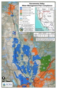
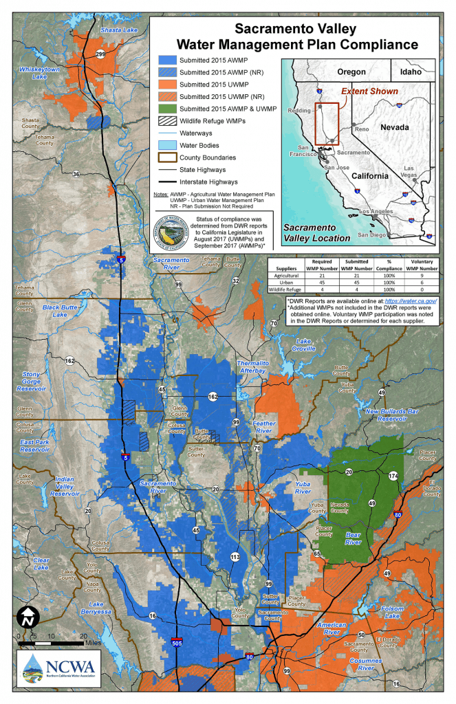
In order to demonstrate the full compliance with state-mandated requirements to develop water management plans (WMPs) by both urban and agricultural water managers in the Sacramento Valley, and to highlight efforts to develop WMPs by those who voluntarily did so, the Northern California Water Association (NCWA) hired Davids Engineering to design and create a map to visually illustrate WMP compliance. WMPs are important for responsible stewardship of water resources on both a local and regional level. Through review of WMP compliance reports from the California Department of Water Resources (DWR) and coordination with NCWA staff and water managers in the Sacramento Valley, WMP compliance was determined. Using Esri’s GIS software package, a map depicting the portions of the Sacramento Valley covered under these plans was developed. More information on this project, including the final product, can be found on the NCWA website here (https://norcalwater.org/2019/05/15/new-map-shows-comprehensive-sacramento-valley-water-resources-management-planning/).

All Projects

Colusa Subbasin Groundwater Sustainability Plan Revisions

Madera Subbasin Groundwater Sustainability Plan Revisions 

Chowchilla Subbasin Groundwater Sustainability Plan Revisions

Moore Siphon Replacement Project

Dos Rios Ranch SB88 Compliance and Crop Planning Analysis

Hart Ranch On-Farm Irrigation Efficiency Improvements

Orland Project Distribution System Modernization

Water Management Plan Compliance Mapping

Agricultural Development Feasibility Assessment

Analysis of Effects of Water Management on Evapotranspiration from Managed Wetlands

Garden Highway Mutual Water Company Water Control Projects

Richvale Irrigation District Phase I Infrastructure Modernization

Joint Water Districts Board SCADA

Sutter Mutual Water Company Modernization Support

Shasta Valley Groundwater Monitoring

Time Series Evapotranspiration and Applied Water Estimates from Remote Sensing

Customer Delivery Measurement Data Collection and Accounting (RemoteTracker Implementation)

SGMA Technical Support Services and Prop 1 Stressed Basin Grant Project

Efficiency Conservation Definite Plan and Conservation Program

Boundary Outflow Measurements

Oakdale Irrigation District Agricultural Water Management Plan

Yuba Water Agency Agricultural Water Managment Plan

Feather River Agricultural Water Management Plan (FRRAWMP)

Colusa Subbasin Groundwater Sustainability Plan Development

Madera and Chowchilla Subbasins Groundwater Sustainability Plans

2022 Verification Project for Madera County GSAs

Little Shasta River Efficiency Study

Mill Creek Flow Measurement Improvements

Kettle Spring Improvement Project

Antelope Creek Fish Passage Improvement Project

Conservation Planning and Operations Decision Support